
Tirunelveli Flood Update: Tirunelveli heavy rain school holiday announcement
11/24/2025
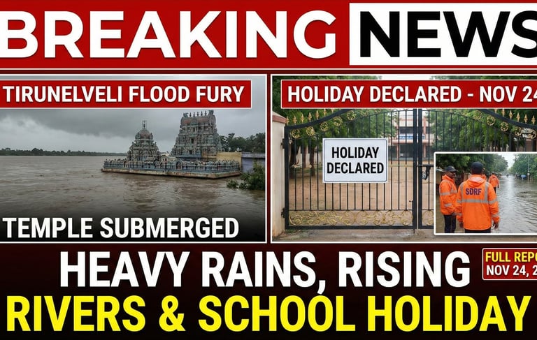
Tirunelveli Flood Update: Heavy Rains, Rising River Levels & Holiday for Schools – Full Report (24 November 2025)
The northeast monsoon has intensified across the southern districts of Tamil Nadu, and Tirunelveli is witnessing one of the heaviest rainfall spells of this season. On Monday, 24 November 2025, continuous overnight rain, flooding across key locations, and rising water levels in the Thamirabarani River pushed authorities to declare a holiday for all schools and colleges in the district. The developing weather system over the Bay of Bengal has significantly increased rainfall activity across the region, creating challenges for residents, farmers, and local authorities.
This detailed blog post covers everything that is happening on the ground — the flood situation, weather updates, safety concerns, agricultural losses, and what residents can expect in the coming days.
Flood Situation: Thamirabarani in Full Flow
The most alarming situation today is the Thamirabarani River, which is flowing at a dangerously high level due to heavy rains in the Western Ghats and upper catchment areas. Continuous inflow has pushed the river to its full spate.
One of the notable locations affected is the Kurukkuthurai Murugan Temple, which is now partially submerged under rising floodwaters. Videos and images circulating locally show fast-moving water surrounding the temple steps, making the area unsafe for the public.
Waterfall Zones Restricted — Flash Flood at Manimuthar
The Manimuthar region, including Manimuthar Falls, continues to remain under strict restrictions. Due to sudden flash floods triggered by heavy rainfall, the forest department has banned public entry for the fifth consecutive day. Rising water levels in the falls and check dam make this area especially risky, and tourists are advised to stay away until further updates from officials.
IMD Warnings: Flash Flood Risks Across Southern TN
The India Meteorological Department (IMD) has issued a flash flood risk alert for Tirunelveli, Tenkasi, Thoothukudi, and Kanniyakumari districts.
Officials have also warned of:
Localised flooding
Strong winds
Sudden water-level rise in rivers and streams
Risky travel conditions near hills and water bodies
Residents living near riverbanks, lakes, and waterfalls have been strongly advised to follow safety guidelines and stay alert for district-level updates.
SDRF Team Deployed for Emergency Response
To handle the worsening weather situation, a team from the State Disaster Response Force (SDRF) has been stationed in Tirunelveli. Their role includes:
Assisting in possible evacuations
Monitoring flood-prone areas
Supporting local administration with rescue operations
Handling emergencies related to heavy waterlogging
With more rainfall expected, authorities may deploy additional teams if required.
Impact on Daily Life: School Holiday & Exam Postponement
The district administration has officially declared a holiday for all schools and colleges today. This includes government, private, aided, and matriculation institutions.
In addition:
Manonmaniam Sundaranar University (MSU) has postponed the semester exams scheduled for today.
Colleges affiliated with MSU will issue revised exam dates soon.
Parents and students are advised to monitor official updates from their institutions.
Agricultural Losses: Banana Plantations Hit Hard
One of the biggest impacts of this rainfall has been on agriculture. Strong winds combined with continuous rain have destroyed over 150 acres of banana plantations in and around Tirunelveli district. Many farmers have reported heavy losses running into several lakhs.
The initial assessment shows:
Entire fields flattened by wind
Water stagnation affecting standing crops
Damage to newly planted banana saplings
Loss of income for upcoming harvest cycles
Farmer associations have appealed for government compensation and immediate relief.
Weather System Behind the Heavy Rain
The current spell of intense rainfall is driven by a combination of two active systems:
1. Cyclonic Circulation Over South Sri Lankan Sea
Moisture-heavy winds from the Indian Ocean and Sri Lankan coast are pushing large rain bands into southern Tamil Nadu.
2. Low-Pressure Area Over Southwest Bay of Bengal
This system is strengthening and feeding continuous rainfall into Tirunelveli, Thoothukudi, Kanniyakumari and nearby districts.
These two systems together are creating:
Non-stop rainfall
Thunderstorm activity
Strong winds
Increased cloud formation
Meteorologists expect these conditions to persist for another 24–48 hours.
Weather Forecast for Tirunelveli Today
According to regional weather models, residents can expect:
Moderate to heavy rain throughout the day
Periodic thunderstorms in the afternoon
Reduced visibility on highways
Risk of waterlogging in low-lying neighbourhoods
Slippery conditions on ghat roads
Travelers are advised to avoid unnecessary long-distance travel today.
Areas to Watch Out For
Based on today’s rainfall intensity, the following areas may experience waterlogging or rising water levels:
Palayamkottai
Pettai
Vannarpettai
KTC Nagar
Cheranmahadevi
Nanguneri
Ambasamudram
Papanasam (river-connected zones)
People living near irrigation channels, “odais,” and tank overflows should remain alert.
Safety Tips for Residents
Here are some essential safety measures recommended by authorities:
Avoid going near riverbanks, especially the Thamirabarani.
Do not attempt to cross flooded roads or bridges.
Keep mobile phones charged in case of power disruptions.
Store drinking water and essentials.
Farmers should avoid entering flooded fields.
Follow IMD, district collector, and police alerts closely.
Avoid visiting waterfalls, forest areas, or hill roads.
With more rain expected, these precautions can help prevent accidents.
What to Expect in the Next 48 Hours
If the Bay of Bengal system intensifies into a depression or weak cyclone, Tirunelveli may continue to receive:
Widespread rainfall
Strong winds
Flash-flood-like conditions near tributaries
Higher inflow into dams
Authorities are monitoring reservoir levels closely to prevent sudden releases that may affect downstream areas
Tirunelveli is facing a challenging weather situation as heavy rainfall continues to lash the district due to strengthened monsoon activity and a developing low-pressure system. The rising water level in the Thamirabarani, flash floods in Manimuthar, agricultural losses, school closures, and the deployment of SDRF all highlight the seriousness of the situation.
Residents are encouraged to remain cautious, follow official advisories, and avoid unnecessary travel today. With rainfall expected to continue, staying updated through reliable sources will help ensure safety for everyone in the district.


Quick Links
Connect
Share
contact@palayamkottai.com
© 2025. All rights reserved.